This product was developed
from the technologies of the following awarded US Patents: US
6,415,227 B1, US 6,622,090 B2 and US 7,143,130
B2, etc.
|
|
Product
Summary:
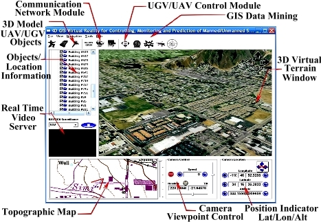
The coremicro 4D GIS system is an
integrated system which brings together the various components,
subsystems within the AGNC coremicro product line. It provides the
user GIS based, three- dimensional virtual/augmented reality interfaces
for controlling, monitoring and prediction of manned/unmanned systems.
FEATURES:
• IP-based Network Communication
Ethernet based communication system for logistic and location information
exchange between the 4D GIS nodes and the manned/unmanned vehicles.
Real time video server enhancing situational awareness.
• Logistic Planning and Task Assignments
Automated task assignments, route planning for various mission scenarios.
• Asset/Environment Monitoring and Management
Real time tracking and monitoring of vehicle assets and mission
status. Multi-layer database with efficient data fusion algorithms
that identify attributes associated with vehicles assets, tasks
requirements, GIS terrain and obstacles.
• Predictive data mining
Based on established database and various pattern features, identifies
possible bottlenecks, and failures before status reaches urgent.
Handles different events with various priorities in a queuing system.
APPLICATIONS
• Ground Sea, and Air Freight Services
Real-time tracking and monitoring of vehicles globally, shipment
routing/re-routing. shipment time estimation, routing center status,
weather conditions, emergency information.
• Emergency Responder
Coordination and tracking of various emergency response agencies,
fire trucks, police vehicles, paramedics, other personnel.
• Network Centric System
Network centric coordination, mission planning for surveillance,
multi-UAV/UGV task assignments.
|